An AI Data Centre is being proposed on the large triangle of land opposite Tesco near Harford Bridge. Data centres are already causing concern in other parts of the country because of their size, energy and water requirements, heat output, etc., etc, …..
The environmental impact of the Centre on the Yare Valley Green infrastructure Corridor could be huge!
Respond now to the pre-planning application consultation which ends on July 12. You can find out more by attending an event at the Keswick Reading Rooms between 3pm and 7pm on July 7 when the plans can be discussed.
Here is a link to what is being proposed: apex Norwich Data Centre . If the link does not work, try using another browser!
The clarity of the Apex site is less than adequate, and so do get along to the event on July 7 if you possibly can.
There are many questions to be asked, and some of the questions the YVS committee will be asking are in the latest Newsletter N128 July 2026.
Please help YVS to safeguard the Valley by responding to a consultation on the likely impact of installing pylons, solar panels, and other energy developments in the Yare Valley.
Pylons on Marston Marsh?
The Background
South Norfolk District Council is consulting on a draft Supplementary Planning Document (SPD) which deals with Landscape Susceptibility in relation to Energy Generation, Storage and Transmission as it relates to Local Character Areas* (LCAs) within its boundaries. It has drafted assessments of how susceptible the LCAs are to the development of solar photovoltaic panels, anaerobic digestion (AD) plants, battery storage facilities, overhead powerlines including 400kV lines that utilise the largest pylons (35-50m), underground cable routes, and substations. Among the LCAs assessed is LCA F1: Yare Valley Urban Fringe which is a part of South Norfolk that lies in the Yare Valley on the south side of the Norwich boundary (the river is the boundary).
The Yare Valley Society is concerned that the present draft susceptibility assessment in the consultation does not take fully into account the special circumstances of LCA F1. It is unique amongst the LCAs of South Norfolk, lying as it does in an urban fringe and forming part of the larger Yare Valley Green Infrastructure Corridor.
YVS is pressing for LCA F1 to have a special status and be included in the main body of the report under its own separate section. The YVS case for special status is here.
For a second submission to South Norfolk Council, YVS is preparing a detailed response to Appendix 3 Landscape Susceptibility Analysis of F1 (Pages 76 to 85). You might like to have a look at this and send in your comments to Planning at South Norfolk (email above).
Thank you for caring for the Valley
*Local Character Area status provides a degree of protection from inappropriate development. In the case of the Yare Valley LCA this is reflected in Policy DM 4.5 Landscape Character and River Valleys: “All development should respect, conserve and where possible, enhance the landscape character of its immediate and wider environment. Development proposals that would cause significant adverse impact on the distinctive landscape characteristics of an area will be refused. …”
The Yare River Valley and the Wensum River Valley are the two strategic green infrastructure corridors of Norwich. Proposed developments continue to threaten their effectiveness in providing habitat and free movement for wildlife. One threat is the building of roads across the valleys. An additional road across the Yare Valley has been mooted, but there is no definite plan as yet. A new road across the Wensum is now under consideration to carry the Norwich Western Link. A planning application (FUL/2024/0022) for the Link has been submitted, and it is out for public consultation until 18th August 2024 (recently extended to this date).
Norfolk Wildlife Trust, CPRE, Friends of the Earth and Buglife are have joined with other environmental organisations to condemn the proposals because of the ecological destruction that can be expected to occur. Natural England has sought assurance from the developers Norfolk County Council that a nationally important habitat for a protected species of bat will not be damaged. Whether Norfolk County Council can give such an assurance seems in doubt, but the Council have, none the less, gone ahead with a planning application for the road.
Grounds for objection are detailed by the “Stop the Wensum Link” campaign.
Concern has also been expressed that the route is designed only for motorised vehicle use (or fearless cyclists) with little or no provision for more sustainable means of travel such as walking and cycling. There is no effective shadow route for non-motorised users.
The issues are complex, but if you wish to speak up for our green wildlife corridors and/or sustainable travel, go to the plans and consultation website.
The latest report of the Rivers Trust classifies the ecology of the Yare as “moderate”. This is on a scale of High, Good, Moderate, Poor or Bad. A map shows the Yare to share this category with most of England’s rivers. Only 15% of rivers are rated as being in “good” ecological health.
River health is moderate. How healthy are these?
Ecological health is assessed by looking at the state of what is living in the river environment. “The presence, absence and abundance of species is a good indication of the general health of a river.”
There is no river in England rated as “good” for chemical health or for overall health.
The detailed State of Our Rivers Reportfor 2024 is an in-depth study of the condition of our rivers and suggestions solutions and actions for improving the health of our rivers.
YVS has already reported on the Norfolk Rivers Trust’s work at various points on the river in the valley to improve water quality by modifying river flow and to improve resilience of wetlands to drought by interconnected scrapes.
The Environmental Agency is funding Norfolk Rivers Trust to work on schemes that will increase meanders in the river, increase the speed of flow of the water, and trap more of the sediment that it transports. At the same time the schemes will improve water quality and provide marginal cover and habitat for river dwellers, such as water voles.
Newly constructed Berm Photo: John Elbro
Woody berms are being installed at various points along the banks of the River Yare between Cringleford Bridge and the UEA campus. The Woody Berms are made up of woody material, mainly alder, layered at the river margins and held tightly in place by stakes and cross braces. In places this has necessitated cutting back some of the vegetation on the banks to provide the materials.
As time passes reeds and other marginal vegetation will become established in the berms to give a more naturalised appearance and create habitat. An idea of what the mature berm might look like can be seen in a Wessex River Trust booklet.
Yare Valley Water Vole Photo: Lynda Clarkson
The Norwich Fringe Project has also been using natural materials to restore sections of bank that have become eroded at Marsden Marsh. It has inserted Faggots at places with serious bank erosion, these will help to consolidate the bank and reduce further erosion.
Bank restoration on Marsden Marsh
Explanatory notices have been put up to explain the works. A clearer map can be found here.
Planning application for hole in the ground “Pond” reduces public green space
Another application, 22/01567/F, has been made relating to the McCarthy Stone phase 3 development on Bluebell Road. The application is for enlarging the attenuation pond constructed for water runoff of phases 1 and 2 to cope with phase 3. The use of “pond” although not technically incorrect may give a misleading picture of what is being proposed. Attenuation ponds for developments can be unsightly and potentially dangerous. An attenuation pond in a public access green space linked into the projected Yare Valley Parkway should be more than a hole in the ground. It should be safe and add to the amenity of the open space rather than detract from it.
Existing Attenuation Pond for phases 1 and 2.
The Yare Valley Society has several concerns about the proposals:
Restriction of public green space
The pond extension as positioned would further restrict the Public Access Green Space being made available under phase 2 of the development (now under construction). It should be a separate pond contained within the original Phase 3 development area.
Size
Insufficient attention has been paid to measures that could reduce the size of the attenuation pond e.g. by a greater use of water permeable surfaces of drives, roads and parking areas etc., and by use of rainwater harvesting (e.g., rainwater tubs, rain gardens) within the site.
Design and Planting
Insufficient attention has been given to its design and planting. It is a large feature in a public green space and so itshould be sculpted to create a natural setting. It should then be planted with trees, shrubs and other plants to improve visual appearance, provide safe public access, and provide habitats for wildlife.
Water Quality
It is not clear what steps are to be taken to ensure the water entering the pond is of sufficiently good quality to avoid hazard to wildlife or to the public.
Management
A Management Regime will need to be put in place to maintain and improve biodiversity, amenity, and water quality of the attenuation pond into the future.
What is possible?
The attenuation pond is a SUD (Sustainable Drainage System), and modern designs for SUDs in public green spaces maximise the potential for SUDs to contribute to the ecology and amenity of their surroundings. Key design principles for SUDS can be found on p 11 of the RSPB publication “Sustainable Drainage Systems – Maximising the potential for people and wildlife” . The publication shows what is possible with foresight and planning.
If you share the YVS concerns, please respond to this application by going to the Norwich Planning website, and inserting the reference 22/01567/F for details. Please make clear in your response why a properly designed and sited attenuation pond is important to you personally. Please act ASAP.
The Yare Valley Society’s submission on the application is here.
Planet Patrol is asking people to head to their local waterways for about 15 minutes around the 14th, 15th, and 16th of October 2022 to report on their condition. It is part of the Planet Patrol Autumn Water Watch programme.
How clean is the water you swing over?
“Water is central to the health, well-being and livelihood of everyone on this planet. In the UK, the biggest risk to water quality is the ongoing lack of sampling, monitoring and reporting. The impact on both human health and the ecosystems that rely on them are still largely unobserved and unreported. Right now we have a monumental information gap that needs to be urgently filled, and that can be started through simple observations – something we can all do.
If you don’t truly understand the problem, how can you solve it?”
To take part you can download their App from the Apple or Google store or you can complete their online form.
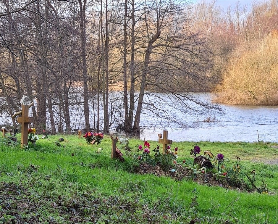
At a Zoom meeting today, the South Norfolk District Council Development Committee approved plans for the extension of the Colney Burial site. The extension borders on the River Yare and the Bowthorpe fishing lakes. It takes the form of a narrow strip close to the river connecting to a larger area to the east of the existing site
At the meeting Colney Parish and the Yare Valley Society expressed concerns before approval was given.
The Yare Valley Society pushed for the Development to safeguard, and where possible enhance, the landscape character of the valley, and for there to be no risk of pollution to the river from the burial site. Colney Parish drew particular attention to the regularity of flooding of some of the site from the river, and the increased pollution that could result.
Flooding near existing burial ground
By a vote of 4 to 1 approval was given subject to a number of conditions that went part way to addressing concerns.
Protection of the landscape and ecology will be addressed by a Landscape and Woodland Management Plan. This will include a commitment to increase the proportion of native trees and to safeguard local wildlife. The protection of a heronry will be included in the plan.
The pollution issue is complex. The Tier Two Groundwater Risk Assessment Survey for the site concluded the site to be high risk with the close proximity of the River Yare contributing significantly to the overall risk.
The Environmental Agency, as recently as November 2019, reported the Yare had unacceptable levels of chemical pollution, and that targets for improvement are likely to be missed. YVS argued that now is not the time to be accepting further pollution of our rivers by new developments. Adding more pollution to the river would not bring the pollution problem under control and would result in further damage to our river ecosystems. Flooding would add a further unknown in assessing the likelihood of river pollution.
The approval was given subject to groundwater monitoring of the site, and a flood evacuation plan being in place.
The YVS continues to be concerned about possible contamination of the river and the effectiveness of monitoring. On the positive side, an effective implementation of a Landscape and Woodland Plan should safeguard the visual attractiveness and the ecology of this part of the Valley for the foreseeable future.
Please note that an Eastern Daily Press article on the decision entitled “The hearses will have to go on boats” should have given the correct names of the representatives of Colney Parish and the Yare Valley Society as Bee Korn and John Elbro respectively.
More than ten days after oil pollution in the river was first reported, and the Environmental Agency inserted booms at the believed point of entry of the pollution into the river, pollution of the river by what appears to be diesel oil continues. Today, 3rd January, the “smell of diesel” remains at the bridge at the bottom of Chancellor’s Drive and a continuous oil slick can be seen moving downstream. Eaton Village Residents Association (EVRA) report the pollution has reached as far downstream as Marston Marsh.
Danger for Ducks
Dog owners can act to avoid their dogs being contaminated, but no such protection can be afforded to the flora and fauna of the valley. The Oil Care Campaign publicises information on the impact of oil in rivers and provides advice on reducing its entry into the environment.
Please continue to report to the Environmental Agency the location of any pollution you see in the River, and so help stop the hazard continuing. The easiest way to do this is to use the Environmental Agency Incident Hotline 0800 80 70 60.