Fallen trees have blocked two of the paths from Bluebell Road to the riverside path. One path is via the Strawberry Field and the other alongside the Cringleford Flyover embankment. YVS enquired with the Norwich Fringe as to the landowners who might be responsible for clearing the blockages. Following the enquiry, the NFP contacted the landowner directly, and the landowner has undertaken to clear the blockage on the path from the Strawberry Field to the river.
Highway tree. Photo: Rachel Hore
It is possible to find a way round the Strawberry Field path, but the other path is blocked for all but the most intrepid. The situation is a little less straightforward for this path because the blocking tree has fallen from the highway’s embankment, and so the Norfolk County Council’s Highways Authority is responsible for clearing it. The landowner is reporting the blockage to the Authority. Hopefully the Authority will also reinstate the fence.
For a number of years, Tim Hill has recorded what he has seen and heard on Marston Marsh. As we enter the new season, Tim looks back on 2023 to inspire us to get out and about to see and hear for ourselves in 2024:
“Chiffchaffs are always the first to arrive. Last year I heard my first on 20th of March and they were singing, or calling, regularly until the middle of October. There was a lone one calling on 25th November about 6 weeks after the last October one.
Blackcaps started singing on 3rd April and stayed until 18th July. A passing bird was heard on 4 September. They do not seem to overwinter here.
Sedge Warbler Photo: JCF
Sedge warblers arrived on 16th of April staying until 18th July with a lone one on 1st August.
Whitethroats arrived on 22nd April, and two grasshopper warblers were heard from 24th April. Whitethroats stayed until 1 August and grasshopper warblers until mid-July with a passing one reeling on 10 August, stopping off on its way south.
Reed warblers were heard from 1st May until 24th July. This was another species heard again after a gap of several weeks with one calling on 3rd September.
The warbler that was only heard once was a willow warbler on 26th April. Many years ago, these were regularly heard in the trees around the entrance to the marsh near Abinger Way. Last year saw the reappearance of Cetti’s warblers of which there were probably two. One was heard at the end of March, and early April, and then two territories were identified with birds calling from 9th September to the end of the year.
Blackcaps tend to be found along the path that runs parallel to the old road, from the style to the main entrance. They can also be found in the woods around the seat by the gate at the Western end of the marsh. Garden warblers, which sound similar, tend to prefer the woods by the river but sometimes are seen above the pair of gates leading onto the marsh after entering from Abinger Way. It takes me a while to get tuned in to the difference between their songs each year and often, when I think I have found one of them it shows itself and is the other. After several weeks my recognition improves greatly.
The sedge warblers prefer the strip of reed running north from the bridge at the east end. As more arrive they start to set up territories along the railway embankment at the west end of the marsh too.
Reed Warbler Photo: JCF
Reed warblers seem to like the same strip of reed as the sedge warblers, and again I have to tune in to the year’s particular birds. Reed warblers also like the reeds either side of the path where the blackcaps are found but stay closer to the gate by the style.
Chiffchaffs and whitethroats can be seen, and heard, in any of the wooded areas around the fringes of the site and are probably the most numerous of the warblers. I would estimate that there may be up to ten chiffchaff territories here and possibly as many whitethroat ones.
Grasshopper warblers prefer the central area of the marsh. They are often heard south of the bank that runs from East to West by the owl box or between the river and the golf tee that is cut back into the woods. I have only had one good sighting in previous years, but I have spoken to people who have seen them more recently and more regularly. Two seems to be the normal population.
Goldcrests are here year-round and prefer conifers or ivy covered trees. They are best detected by their reeling song or high-pitched call and can take some time to get a good view of.”
Good news for 2024 is that by the 23rd of January Tim had seen 51 species on Marston Marsh which equals the total for all of January 2023. (Update on 2nd February: Total for all of January 2024 turned out to be 54, a red kite was in the last three of the month).
A member of the YVS committee recently noticed some of the netting on the UEA boardwalk, laid to minimize the chance of slipping, had come loose and had become a tripping hazard. She reported it UEA and they carried out a prompt repair. Unfortunately, it became apparent that the whole of the boardwalk requires further maintenance, and for safety reasons the boardwalk has been closed. UEA has yet to decide when the remedial work can be carried out.
Thanks for a prompt repair.
Photo: Rachel Hore
In the meantime notices have been posted to show a diversion of the Yare Valley Walk around the boardwalk, leading it away from the river on to slightly higher ground.
Not that way today.
Photo: Rachel HoreThe diversion.. Photo: Rachel Hore
Norwich has two “chalk streams” the rivers Yare and Wensum. Chalk streams and their associated ecology are very rare globally. In spite of some statutory environmental protections being in place, not infrequently there is a need for groups drawn from the general public to support and reinforce these protections.
For both rivers there is the Norfolk Rivers Trust. Its mission is to restore, protect and enhance the water environments of Norfolk for people and wildlife.
The Yare has the Yare Valley Society. It seeks to promote the enhancement of the river valley for wildlife and informal recreation from Bawburgh to Whitlingham Country Park.
The Wensum too has people who are prepared to act to avoid damage to its ecology. The Norfolk Wildlife Trust, supported by Aviv in a public appeal for funds, raised money to enable them to purchase the Sweet Briar Marshes beside the Wensum in Norwich. The Trust is in process of seeing through a plan to improve the marshes’ ecology and also to provide some public access.
More recently the single-issue group “Stop the Wensum Link” has drawn attention to the threat the proposed Norwich Western Link presents to the ecology of the Wensum. The latest stage of their campaign is a “Great Big March”:
It is encouraging for all who care for the environment that so many ordinary people, and some extraordinary people, are now backing groups that are attempting to reverse, or at least to halt, the present decline in the ecology of the UK.
In recent days the Yare Valley has again been fulfilling two of its major roles in combating climate change: mitigating its effects and providing resilience. Its marshes, commons and meadows have become storage basins for many cubic metres of flood water slowing down its rush to the sea and lessening the chance of inundation of properties downstream.
Marsden Marsh from Marsden Lane seat. Photo: John Elbro
We have been deprived of some of our favourite walks, but it is a small price to pay. As compensation there are dramatic views to enjoy. Other obstructions to paths have been fallen trees after storm Henk, but normally a way can be found round or over these.
Bridleway to Keswick Mill from Church Lane. Photo: John ElbroFallen Tree on path to river from Strawberry Field. Photo: Paul Hann
The depth water on the bridleway was over welly height and rising!
The attenuation basins constructed under the supervision of the Norfolk Rivers Trust below the Strawberry Field have been inundated. As the waters recede the basins will retain water to increase the resilience of the marsh in times of drought and so help safeguard the habitats of water voles and other wildlife.
Inundated attenuation ponds below Strawberry Field. Photo: Paul Hann
For some it may be the bleak midwinter, but the conservation volunteers will be keeping warm with their conservation work in Norwich and the surrounding area. Details of their programme and how to join are here. The organiser, Mark Webster thanks the volunteers for all their efforts in the past year. Between 01 Jan 2023 and 31 Dec 2023:
· 221 tasks were delivered
· 109 different registered volunteers were involved
· 2046 workdays
· 53 different sites were worked on
· 15 sites (28.3%) are in the most deprived 20% of neighbourhoods
· Average of 8.4 individuals per task
Now looking forward to a successful volunteering year in 2024.
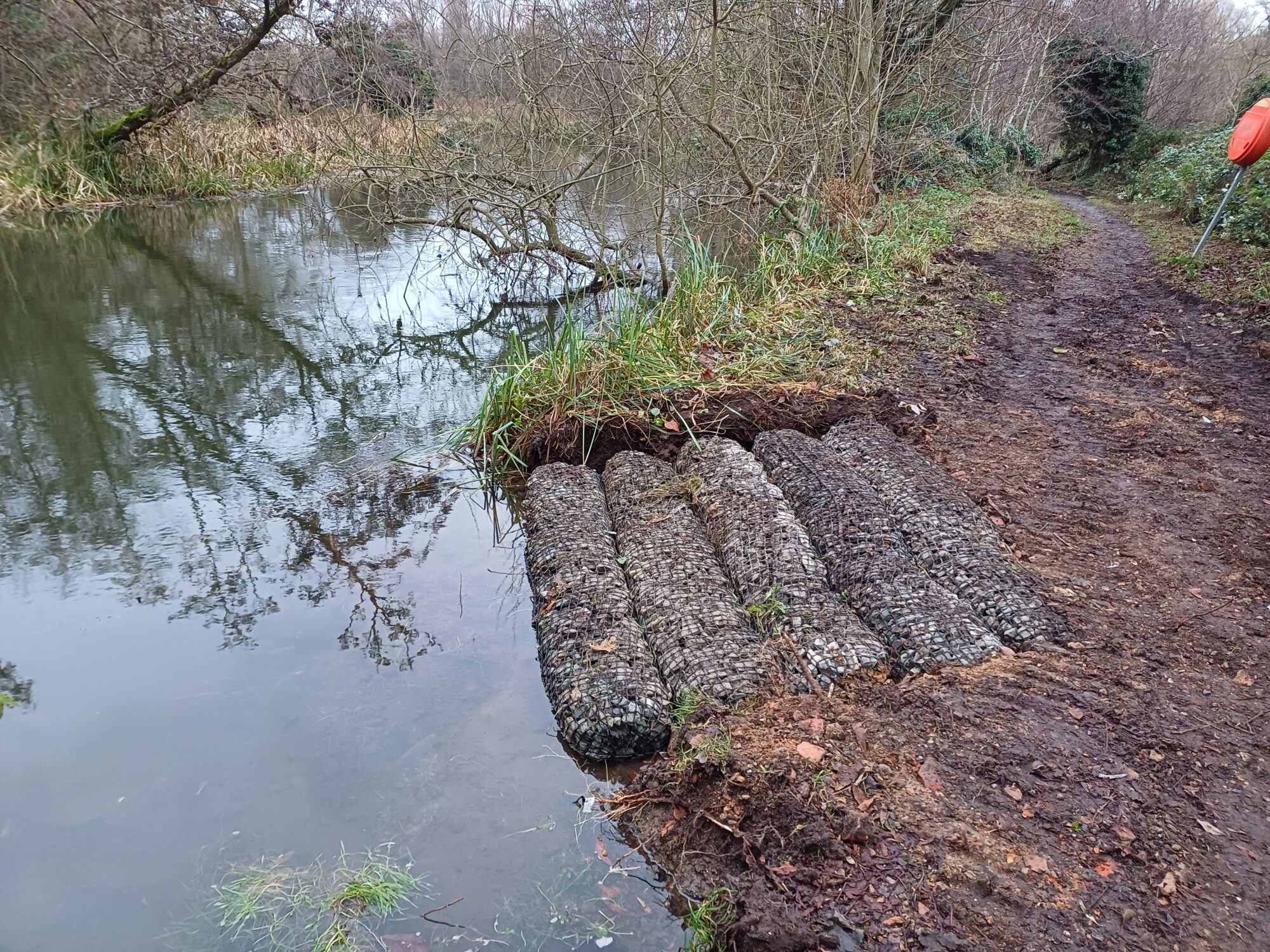
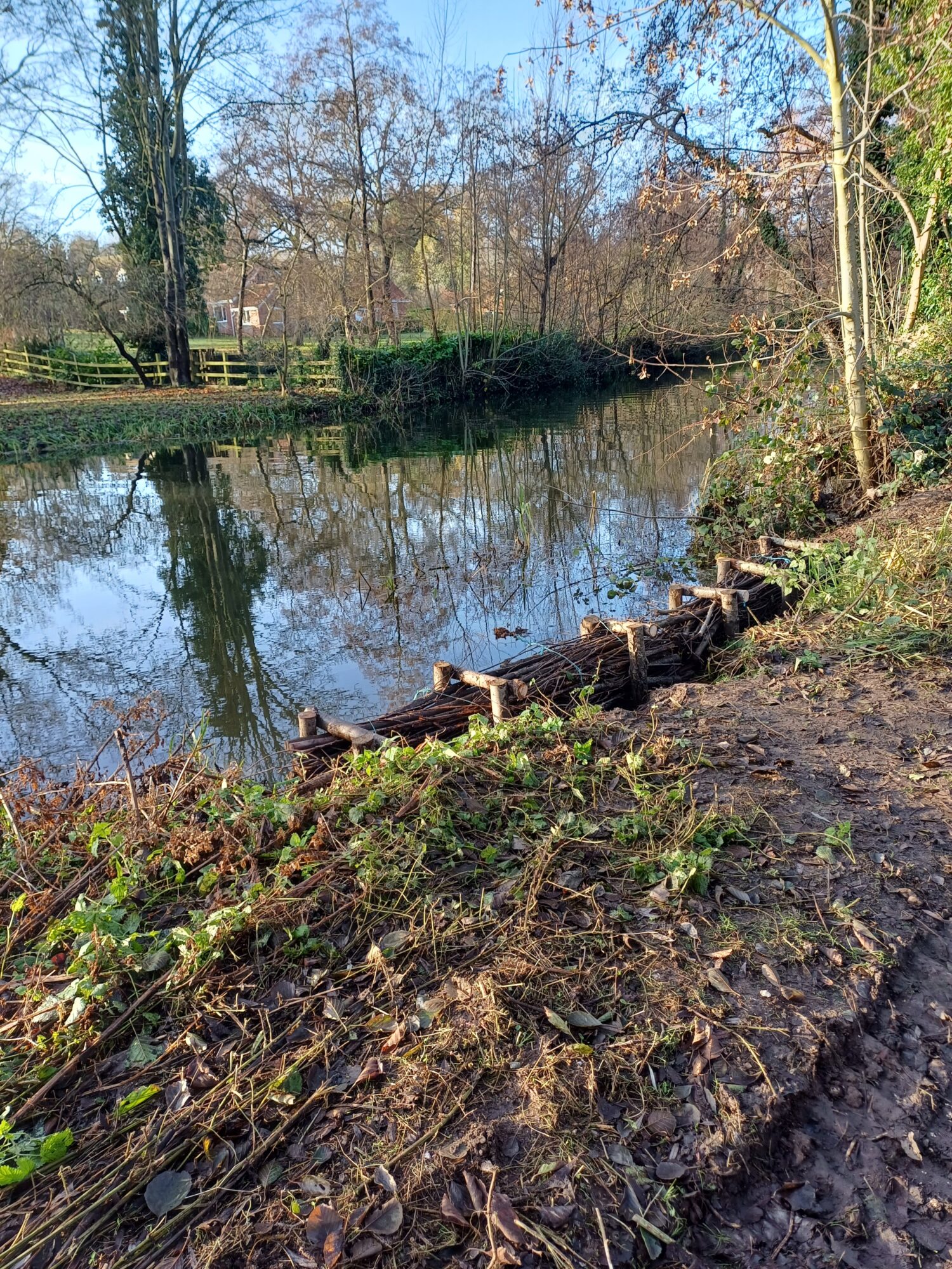
Work has now started on improving the Yare Valley Walk between Cringleford Meadow and Strawberry Field. The first stage is to reinforce the riverbank that has become seriously eroded in recent years.
River work Photo: Paul Hann
The works are being carried out to fulfil a condition on the granting of planning permission for the McCarthy Stone development on Bluebell Road.
River Work Photo: Paul Hann
The next stage in the work should be to make much needed path improvements to the path surface on this section of the Yare Valley Walk.
The Friends of Strawberry Field and UEA meadows have changed their name to “The Yare Valley Meadow Makers” to better describe and emphasize their practical “in field” activities. They also have a new logo:
YVS members will recall that Matt Tomlinson gave a very well received talk about his vision for the meadows at the 2021 AGM. He founded the Friends group three years ago. The group has worked with the landowner of the Strawberry Field to make changes to the management of the field so as to better achieve the group’s long term aim of creating a rich community wildflower meadow. Spurred on by successes in the Strawberry Field the group also became involved in assisting with the nearby hay meadow at UEA. The most recent activity was to scatter yellow rattle seed at the UEA meadow. Yellow rattle is a well-known meadow maker.
“Here is our November programme for conservation volunteering activities, and it’s an exciting one! Of course, they are all exciting in their way, but this month sees us go to FOUR brand new sites! We are creating a new wildflower meadow near the village hall in Upton, building a “dead hedge” (fence from natural materials) in Wymondham, rejuvenating a woodland in Sprowston, and starting work on a new area in Rouen Road in the centre of Norwich. Creating new wildflower meadows is a bit of a theme this month, as we are also planting seeds and bulbs at Horsford, Earlham Cemetery and in Wensum Park. A number of students have been asking me about our Volunteer Officer programme (internships). If anyone is able to spend a few months with us (could be full or part-time, we are very flexible) they can learn everything that they need to know to get a paid job in nature conservation. … “
More details of internships and the programme are here.